Distance
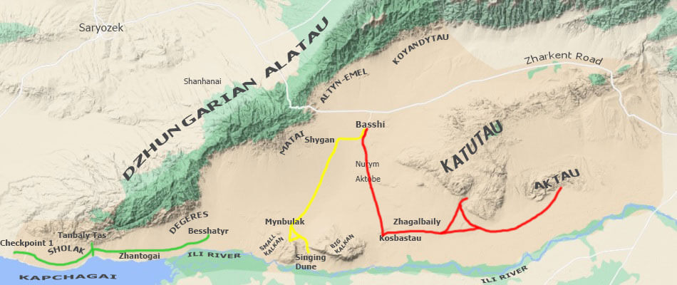
Distance of the tourist route: 35 km one way (Checkpoint 1 - Besshatyr mounds, the route is marked in green on the map).
Checkpoint 1 → 17 km → Tanbaly Tas petroglyphs → 9 km → Zhantogai post → 9 km → Besshatyr burial mounds → 35 km → Checkpoint 1.
Besshatyr and Tanbaly Tas: Trail of Saka Nomads
This is a special tourist route in the southwestern part of the Altyn-Emel National Park. In this place, the outermost spurs of Dzhungarian Alatau (the Sholak Mountains) almost reach the floodplain of the Ili river (in the place where it flows into the Kapchagai reservoir), forming a narrow entrance to the valley.
Here, in the foothills of Sholak, numerous petroglyphs of the Bronze Age, Saka epoch (I millennium BC), the Middle Ages and so on, up to the present, are scattered on the rocks. Besides pagan symbols, the Tanbaly Tas petroglyphic complex also includes Buddhist inscriptions. Scientists suggest that one of the abodes of Buddhist lamas could be located in this area.
There is a complex of the Besshatyr royal burial mounds in the valley nearby. These are the tombs of the leaders of the Saka Tigrahaud (Tigrahauda, Tigraxauda) nomadic tribe, which inhabited this territory in the 6th-4th centuries BC.
The grandiose mounds which look like pavilions from afar, along with altars and menhirs surrounding them, stand solemnly in the silent steppe, the whole scene keeping its ancient appearance up to now.
Previously, this part of the Altyn-Emel National Park was not isolated (from here it was possible to drive straight to the Singing Dune), but later it was decided to close the passage in order to preserve the protected area for wild animals descending from the Sholak, Degeres and Matai mountains to the Ili river for watering.
Places to Visit
Mounds of Besshatyr ("five tents"), dating back to the 1st millennium BC is the main historical and cultural attraction of Altyn-Emel.
Large, medium and small tombs were erected for leaders, commanders and nobility of the nomadic tribe of Saka Tigrakhauda who lived on the territory of Semirechye (Jetysu, "Seven Rivers") about 2.5 thousand years ago. The Besshatyr necropolis also served as a place for religious ceremonies.
Petroglyphs of Tanbaly Tas ("stone with signs") on the territory of Altyn-Emel is part of one of the world's largest centers of rock art, which stretches along the belt of mountains and foothills from Sayans and Altai to Tien Shan and Pamirs.
Carved on stone, drawings of people, animals, sun-headed deities, etc., belong to the era of bronze, iron and the Middle Ages.
The place where the Ili river flows into the artificially created Kapchagai reservoir, forming a vast fore-delta, is located in the protected part of the Altyn-Emel Park.
This is a quiet and picturesque place with the the Kapchagai lake, on the one hand, and the south-end of Dzhungarian Alatau (the Sholak mountains), on the other.
See also:
Alert
Tourist Route 2 (Tanbaly Tas Petroglyphs and Besshatyr Mounds) is open for visiting only during the daytime, during daylight hours.
Pass is issued only remotely, in advance through the online cashiers of the national park and payment through the Kaspi Bank mobile application.
There is almost no mobile communication in the park and the Internet does not work.
Overnight stays, camping on the shore of Kapchagai and fishing are prohibited.
Through drive to the Singing Dune is prohibited.
The road along Route 2 is very bad, hilly and rocky in places, it is recommended to have a strong and reliable SUV.